Gudauri
Natural avalanches are unlikely, human-triggered avalanches are possible. Small avalanches in specific areas, or large avalanches in isolated areas.
Recent snow and a period of wind bring a possibility of windslabs up high, and lower down the snow is wet with a danger of wet loose and glide avalanches. There are still areas of buried weak snow in the high alpine. Overall danger stays the same but the problems are a little different - read the full details by clicking on the current forecast.
Forecast issued at: 8 April 2024 09:00
Forecast valid until: 10 April 2024 09:00
Forecaster: Manu Greer
High Alpine
> 2600m
2 Moderate
Heightened avalanche conditions on specific terrain features. Evaluate snow and terrain carefully; identify features of concern.
Alpine
2000m - 2600m
2 Moderate
Heightened avalanche conditions on specific terrain features. Evaluate snow and terrain carefully; identify features of concern.
Sub Alpine
< 2000m
2 Moderate
Heightened avalanche conditions on specific terrain features. Evaluate snow and terrain carefully; identify features of concern.
Avalanche Problems
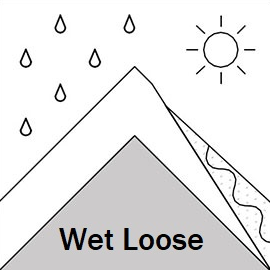
Loose Wet

Wet snow and light rain at lower elevations, and the chance of some sunny breaks with a rising freezing level, continue the danger of wet loose slides from steep areas.
| Sensitivity | The specific avalanche problem type is reactive to human rider triggers. Easy to trigger with ski cut. |
| Distribution | Many locations. Evidence for instabilities is frequently found, in many locations. |
| Time of Day | All day |
| Trend | Deteriorating |
| Confidence | Moderate |
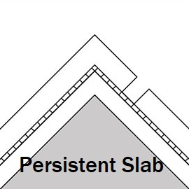
Persistent Slab

On high alpine areas buried instabilities can still be found. They are more likely to be found on northern slopes and areas with a low snow depth.
| Sensitivity | The specific avalanche problem type is difficult to trigger with a human rider. |
| Distribution | Specific areas, with common characteristics. Evidence for instabilities exists, but it is not obvious and finding it requires careful observations. |
| Time of Day | All day |
| Trend | Improving |
| Confidence | Moderate |
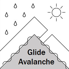
Glide

Such avalanches are now present even as high as 2900 m and are becoming more and more widespread. These are unlikely to be triggered by a rider and often happen naturally so should be taken into consideration while traversing areas below the spots where such avalanches might occur - steeper slopes with grassy or smooth rock underlying surface and slopes where the glide cracks are visible.
| Sensitivity | The specific avalanche problem type is difficult to trigger with a human rider. |
| Distribution | Specific areas, with common characteristics. Evidence for instabilities exists, but it is not obvious and finding it requires careful observations. |
| Time of Day | Afternoon |
| Trend | No change |
| Confidence | Moderate |
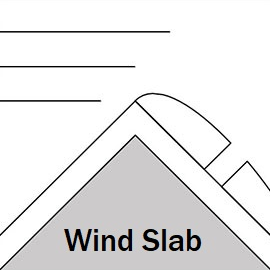
Wind Slab

New snow and a period of strong winds up high mean you could find areas of windslab around ridges on S aspects, and these could be poorly bonded to a melt-freeze crust.
| Sensitivity | The specific avalanche problem type is reactive to human rider triggers. Easy to trigger with ski cut. |
| Distribution | Specific areas, with common characteristics. Evidence for instabilities exists, but it is not obvious and finding it requires careful observations. |
| Time of Day | All day |
| Trend | Improving |
| Confidence | Moderate |
Recent Avalanches and Snowpack
Recent avalanche activity:
05 April - 1 size 2 and 3 size 1 slab avalanches triggered by gas-ex machine near Kobi pass, S aspect 2900 m.
03 April - multiple size 1-2 glide and wet avalanches Kobi valley SE and E aspects 2700 - 2900 m.
Snowpack:
A up to 20 cm of snow in the last couple of days in the high alpine zone and some high N winds on Sunday night may have formed small areas of slab near ridges. The snowpack received a large amount of heat recent before the last storm. Melt freeze crust will be widespread near the surface and the snow is mostly moist and consolidated except in high alpine areas. Weaknesses associated with crusts and facet layers are now less active but should not be ruled out - slab avalanches have been associated with these layers recently. At lower elevations the snowpack will be isothermal (close to zero degrees throughout) and unstable when the surface crust breaks down.
Weather
Cloudy with light snow showers and sunny breaks possible over the next 2 days. E and SE winds, mostly light. Freezing level 2650 m Monday, 2950 m Tuesday.
Disclaimer
Our avalanche forecasters are internationally qualified and experienced professionals, and data is provided by skilled observers. We encourage you to make your own observations and decisions, without relying solely on our forecast, since any forecast is a generalised 'best guess', and in certain cases it might be inaccurate. We can not be held liable for any actions you take in the backcountry that may result in injury, loss or death.