Gudauri
Natural avalanches are possible, human-triggered avalanches are likely. Small avalanches in many areas, or large avalanches in specific areas, or very large avalanches in isolated areas.
Over 50 - 60 cm of new snow haven fallen during Saturday 27 Jan, creating a widespread storm snow (new snow) problem. This new snow does not bond well with some previous surfaces, and there could also be failures within the new snow layer due to the rapid snowfall rate. A storm (new) snow avalanche could also trigger buried and stubborn wind slabs. Weak layers deeper in the snowpack exist in some places and investigation is recommended. The skiing is likely really good in the coming days, but the new snow needs time to settle - until then, keep it low-angle, avoid avalanche paths and run-out zones and watch what (and who) is above you.
Forecast issued at: 27 January 2024 23:00
Forecast valid until: 28 January 2024 23:00
Forecaster: Peter S
High Alpine
> 2600m
3 Considerable
Dangerous avalanche conditions. Careful snowpack evaluation, cautious route-finding and conservative decision-making essential.
Alpine
2000m - 2600m
3 Considerable
Dangerous avalanche conditions. Careful snowpack evaluation, cautious route-finding and conservative decision-making essential.
Sub Alpine
< 2000m
3 Considerable
Dangerous avalanche conditions. Careful snowpack evaluation, cautious route-finding and conservative decision-making essential.
Avalanche Problems
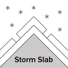
Storm Slab

Over 50 -60 cm of new snow accumulated in the alpine and subalpine on Saturday, 27 January, and there will likely be more new snow in many areas of the high alpine. This new snow is likely to form natural and skier-triggered avalanches. The new snow does not bond well with the previous snow surface where it was hard, crust, or wind-scoured, and there can also be failures within the new snow layer due to the rapid snowfall rate. With relatively low temperatures, this new snow layer will take at least another 24 - 48 hours to settle. Wind forecasts are uncertain. Variable winds on Saturday and possibly stronger north winds on Sunday, the new snow may also form wind slabs in the high alpine.
| Sensitivity | The specific avalanche problem type is reactive to human rider triggers. Easy to trigger with ski cut. |
| Distribution | Many locations. Evidence for instabilities is frequently found, in many locations. |
| Time of Day | All day |
| Trend | Improving |
| Confidence | Moderate |
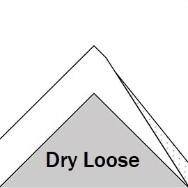
Loose Dry

Unconsolidated new snow can cause natural dry loose snow avalanches on steep slopes but can also be triggered by skiers on lower-angle terrain.
| Sensitivity | The specific avalanche problem type is reactive to human rider triggers. Easy to trigger with ski cut. |
| Distribution | Many locations. Evidence for instabilities is frequently found, in many locations. |
| Time of Day | All day |
| Trend | Improving |
| Confidence | Moderate |
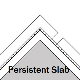
Persistent Slab

Weak layers associated with melt-freeze crusts or density changes have been found in a couple of spots around the forecast area, and cold temperatures are likely to be making these layers weaker. These weaknesses probably need a large load to set them off, but with new snow adding weight, watch this space! Probably only found in isolated areas, although there is still uncertainty - we need more information, so please let us know what you find out there.
| Sensitivity | The specific avalanche problem type is difficult to trigger with a human rider. |
| Distribution | A few, isolated locations; evidence for instabilities is rare and hard to find. |
| Time of Day | All day |
| Trend | No change |
| Confidence | Moderate |
Recent Avalanches and Snowpack
Avalanche Activity:
25th January - natural size 1 windslab observed, S aspect 3000m (happened on 24th)
24th January - 2 x skier-triggered size 1windslabs, SW and W aspects, Bidara W, 2700m. Size 1 loose dry slides observed, steep high alpine areas.
Snowpack: Significant amounts of new snow have fallen on Saturday 27 January. This new snow will be unstable for at least 24 - 48 hours after the end of the storm. Previous wind slabs at higher elevations have become less reactive. The deeper snowpack is generally stable, especially lower elevations (under 2000 m) due to several melt-freeze cycles. Recent warm temperatures formed a crust below 2600 m - 3000 m, depending on aspect. In some areas higher up (above 2600 m), weak, faceted snow was found in shallow rocky areas near ridges, and a crust/facet layer was also seen around 3000 m, E aspect. With colder temperatures, these layers will need to be watched carefully. Some uncertainty remains about surface hoar under the recent snow, which may have survived in sheltered areas above 2500 m. However, we have not yet seen evidence that this is a problem. Check out recent snow profiles (or add your own!) at snowpilot.org
Weather
50 - 70cm new snow fell overnight Friday and into Saturday, stopping by mid-afternoon. Temperatures were cold and not much wind accompanied this snowfall.
Sun and cloud with snow showers possible on Sunday, light to moderate N/NW winds, freezing level 1100m
Disclaimer
Our avalanche forecasters are internationally qualified and experienced professionals, and data is provided by skilled observers. We encourage you to make your own observations and decisions, without relying solely on our forecast, since any forecast is a generalised 'best guess', and in certain cases it might be inaccurate. We can not be held liable for any actions you take in the backcountry that may result in injury, loss or death.