Gudauri
Natural avalanches are unlikely, human-triggered avalanches are possible. Small avalanches in specific areas, or large avalanches in isolated areas.
Reports of wind transport Wednesday morning suggest that wind slabs are developing on S and SE aspects. Up to 30cm of new snow might make storm slab avalanches possible to trigger in some areas, especially if there was any previous surface hoar (a weak surface layer), or at higher elevation where winds may have affected the snow making it denser. Triggering loose sluff avalanches in steep areas is likely. Weak snow layers have been seen within the snowpack in some places - be cautious around ridges and areas of shallow snow. We are a bit short on recent observations so our confidence is not high until we get more information coming in.
Forecast issued at: 24 January 2024 08:00
Forecast valid until: 26 January 2024 08:00
Forecaster: Manu Greer
High Alpine
> 2600m
2 Moderate
Heightened avalanche conditions on specific terrain features. Evaluate snow and terrain carefully; identify features of concern.
Alpine
2000m - 2600m
2 Moderate
Heightened avalanche conditions on specific terrain features. Evaluate snow and terrain carefully; identify features of concern.
Sub Alpine
< 2000m
2 Moderate
Heightened avalanche conditions on specific terrain features. Evaluate snow and terrain carefully; identify features of concern.
Avalanche Problems
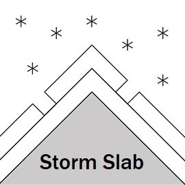
Storm Slab

The recent new snow could form storm slab avalanches in steeper areas especially in the high alpine where it will have been moved by light to moderate S winds. There may be other areas in the alpine zone where the new snow is sitting on surface hoar.
| Sensitivity | The specific avalanche problem type is reactive to human rider triggers. Easy to trigger with ski cut. |
| Distribution | A few, isolated locations; evidence for instabilities is rare and hard to find. |
| Time of Day | All day |
| Trend | Improving |
| Confidence | Low |
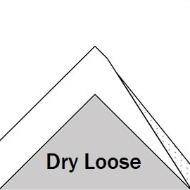
Loose Dry

On steep slopes, small 'sluff' avalanches are likely due to cold, dry snow that has not had time to settle and bond. Be aware of your run-out if you trigger one of these as it could easily knock you off your feet.
| Sensitivity | The specific avalanche problem type is reactive to human rider triggers. Easy to trigger with ski cut. |
| Distribution | Many locations. Evidence for instabilities is frequently found, in many locations. |
| Time of Day | All day |
| Trend | Improving |
| Confidence | Moderate |
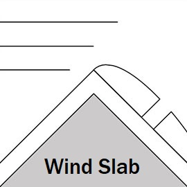
Wind Slab

Winds from the N and NW are moving the light dry snow and will be forming areas of sensitive slab on S and SE slopes in the high alpine. They could be up to 60 cm deep.
| Sensitivity | The specific avalanche problem type is reactive to human rider triggers. Easy to trigger with ski cut. |
| Distribution | Specific areas, with common characteristics. Evidence for instabilities exists, but it is not obvious and finding it requires careful observations. |
| Time of Day | All day |
| Trend | Deteriorating |
| Confidence | Moderate |
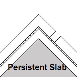
Persistent Slab

Weak layers associated with melt-freeze crusts or density changes have been found in a couple of spots around the forecast area, and cold temperatures are likely to be making these layers weaker. These weaknesses probably need a large load to set them off, but with new snow adding weight, watch this space! Probably only found in isolated areas, although there is still uncertainty - we need more information, so please let us know what you find out there.
| Sensitivity | The specific avalanche problem type is difficult to trigger with a human rider. |
| Distribution | A few, isolated locations; evidence for instabilities is rare and hard to find. |
| Time of Day | All day |
| Trend | No change |
| Confidence | Moderate |
Recent Avalanches and Snowpack
Avalanche Activity:
Reports of new glide slabs near the ski resort over the last few days.
Snowpack: 20-30 cm of new snow without much wind has fallen over the last 48 hours on a generally stable snow pack. N winds are now moving this snow at higher elevations. The snow surface was moist below 2600m due to warm temperatures before the storm. Cold temperatures are now re-freezing the moist snow, but may also weaken some layers deeper in the snowpack at higher elevations. Weak surface hoar crystals were seen in some shady areas in the alpine zone before the snow fell. Most surface hoar has probably been destroyed by mild temperatures or winds, but it might have survived in isolated places - check your slope before you drop. Weak, faceted snow can be found in shallow rocky areas near ridges at higher elevations, and a crust/facet layer was also seen around 3000m, E aspect. Remember that glide cracks and glide slab avalanches are an ever-present danger in this area, and they release at random times - don't stop below them. Check recent profiles at snowpilot.org
Weather
The temperature dropped during the storm over the last 2 days and there has not been much wind. Up to 30cm has accumulated, with most falling on Monday and Monday night.
Cool temperatures forecast for the next 2 days (freezing level 1050m and Wednesday and 1400m on Thursday) with mostly sunny conditions and light and variable winds, but a period of moderate NW winds on Wednesday.
Disclaimer
Our avalanche forecasters are internationally qualified and experienced professionals, and data is provided by skilled observers. We encourage you to make your own observations and decisions, without relying solely on our forecast, since any forecast is a generalised 'best guess', and in certain cases it might be inaccurate. We can not be held liable for any actions you take in the backcountry that may result in injury, loss or death.