Gudauri
Natural avalanches are possible, human-triggered avalanches are likely. Small avalanches in many areas, or large avalanches in specific areas, or very large avalanches in isolated areas.
New windslabs have formed on N and E aspects and snow transport from the W will continue on Saturday. It's not looking like a great weekend for off-piste touring, with sensitive new slabs and extreme cold. The cold temperatures may slow glide activity but may also further weaken snow layers in some areas. Areas of shallow snow (<1 m) at high elevations in rocky areas and near ridgelines should be approached with caution.
Forecast issued at: 12 January 2024 21:00
Forecast valid until: 14 January 2024 21:00
Forecaster: Manu Greer
High Alpine
> 2600m
3 Considerable
Dangerous avalanche conditions. Careful snowpack evaluation, cautious route-finding and conservative decision-making essential.
Alpine
2000m - 2600m
3 Considerable
Dangerous avalanche conditions. Careful snowpack evaluation, cautious route-finding and conservative decision-making essential.
Sub Alpine
< 2000m
2 Moderate
Heightened avalanche conditions on specific terrain features. Evaluate snow and terrain carefully; identify features of concern.
Avalanche Problems
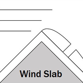
Wind Slab

Moderate to strong S and W winds are moving cold dry snow and forming new wind slabs thoughout Friday and Saturday above 1800m, N and E aspects, on top of previous slabs from a couple of days ago which could still be unstable. The new slabs are easy to trigger and could be up to 40 cm deep. Be very cautious on wind-loaded slopes below ridges and roll-overs or where you see build-ups or 'pillows' of harder snow on steep slopes.
| Sensitivity | The specific avalanche problem type is highly reactive to human rider triggers. |
| Distribution | Specific areas, with common characteristics. Evidence for instabilities exists, but it is not obvious and finding it requires careful observations. |
| Time of Day | All day |
| Trend | Deteriorating |
| Confidence | Moderate |
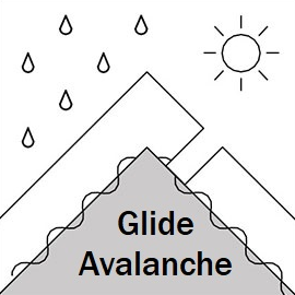
Glide

Glide cracks and full-depth glide avalanches are common around this area, and this time of year they begin to be more of a problem as the snowpack gains weight. These avalanches can release randomly on all aspects, even at night, although rapid warming makes them more likely. This problem will continue for the rest of the season. Do not stop under steep areas if there are cracks above you. Remember that new snow or wind-drifting can disguise these cracks.
| Sensitivity | The specific avalanche problem type is difficult to trigger with a human rider. |
| Distribution | A few, isolated locations; evidence for instabilities is rare and hard to find. |
| Time of Day | All day |
| Trend | No change |
| Confidence | Moderate |
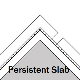
Persistent Slab

A weak layer above a melt-freeze crust has been found near the ski area. It likely needs a large trigger, such as a smaller avalanche, to set it off. Only found on an East aspect so far, but may also exist on South and West too in certain spots. Recent cold temperatures may be weakening this layer - we need more information on it. Have a dig, and let us know your observations!
| Sensitivity | The specific avalanche problem type is difficult to trigger with a human rider. |
| Distribution | A few, isolated locations; evidence for instabilities is rare and hard to find. |
| Time of Day | All day |
| Trend | Deteriorating |
| Confidence | Low |
Recent Avalanches and Snowpack
Avalanche Activity:
12th January, skier triggered windslab, size 1, Kobi valley below the resort, NE, 2350m, 15cm deep, 20-30m wide.
11th January - multiple size 1 - 2 storm and wind slabs seen on E, NE and S aspects, 2200 - 3000m, Chrdili, Khada and Lomisa - Miketi ridge. New glide slabs also observed.
10th january, size 1 skier triggered windslab, Kobi Valley, 2300m, E aspect, 20cm deep.
8th January - multiple new glide slabs up to size 2 seen around Gudauri backcountry, most aspects below 3000m.
Snowpack:
S winds were stronger than expected today and formed windslabs on N and NE aspects above 2000m. 30-35cm of new snow fell on Jan 9th with light winds at lower levels but moderate to strong SW winds higher up. Yesterday (11th) the snow was well-bonded with good skiing at lower elevations. The previous snowpack seemed mostly stable with no concerning failures in recent tests on N aspect 2100m and NE aspect 3000m. Faceted snow has been found in shallow rocky areas near ridges. A melt-freeze crust with facets above has been found on an E aspect at 2970m, Bidara. Below about 1700m a melt-freeze crust has formed.
Check recent profiles at snowpilot.org
Weather
Cold temps and stong S winds blowing through Kobi pass today (12th), transporting snow. 30-35cm new snow Jan 9th with strong SW - W winds in the high alpine, lighter winds lower down, cold temperatures without much wind on 10th and 11th.
Forecast: Saturday 13th, mostly sunny with some clouds and modreate to strong winds from the W 1/4. Very cold temps with a midday freezing level of 350m - minimum temp of -20 at the top of the resort!!! Wrap up warm! Sunday is just as cold with lighter winds and cloud and a chance of snow showers later in the day.
Disclaimer
Our avalanche forecasters are internationally qualified and experienced professionals, and data is provided by skilled observers. We encourage you to make your own observations and decisions, without relying solely on our forecast, since any forecast is a generalised 'best guess', and in certain cases it might be inaccurate. We can not be held liable for any actions you take in the backcountry that may result in injury, loss or death.