Gudauri
Natural avalanches are unlikely, human-triggered avalanches are possible. Small avalanches in specific areas, or large avalanches in isolated areas.
Strong winds on Jan 6th created windslabs that could be triggered by a single skier in some places - e.g. steep convex slopes and near ridgelines. The new snow may also release as small (size 1) dry sluffs in steep areas or wet loose avalanches on SE, S, and SW aspects due to solar radiation and warming temperatures. There have been reports of isolated surface hoar in wind-sheltered areas, some of which might have survived winds and could be buried as a weak layer under new snow. Also, watch for faceted, shallow (<1 m), and weak snowpacks, especially in rocky areas and below ridgelines.
Forecast issued at: 6 January 2024 22:00
Forecast valid until: 8 January 2024 22:00
Forecaster: Manu Greer
High Alpine
> 2600m
2 Moderate
Heightened avalanche conditions on specific terrain features. Evaluate snow and terrain carefully; identify features of concern.
Alpine
2000m - 2600m
2 Moderate
Heightened avalanche conditions on specific terrain features. Evaluate snow and terrain carefully; identify features of concern.
Sub Alpine
< 2000m
1 Low
Generally safe avalanche conditions. Watch for unstable snow on isolated terrain features.
Avalanche Problems
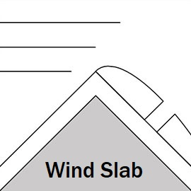
Wind Slab

Moderate to strong winds with from SW and NW with considerable amounts of new snow snow have created windslabs that may still be triggered.
| Sensitivity | The specific avalanche problem type is reactive to human rider triggers. Easy to trigger with ski cut. |
| Distribution | Specific areas, with common characteristics. Evidence for instabilities exists, but it is not obvious and finding it requires careful observations. |
| Time of Day | All day |
| Trend | Improving |
| Confidence | Moderate |
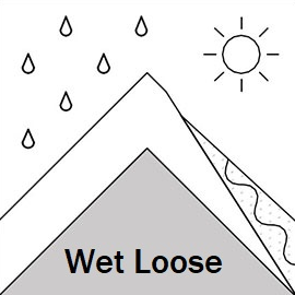
Loose Wet

Especially at lower elevations, as the new snow layer heats up, expect it to form small avalanches in steep areas.
| Sensitivity | The specific avalanche problem type is reactive to human rider triggers. Easy to trigger with ski cut. |
| Distribution | Specific areas, with common characteristics. Evidence for instabilities exists, but it is not obvious and finding it requires careful observations. |
| Trend | No change |
| Confidence | Moderate |
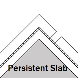
Persistent Slab

Facetted, weak layer above a melt-freeze crust. Only found on an E aspect so far, but may also exist on S and W too in certain spots. Have a dig.
| Sensitivity | The specific avalanche problem type is difficult to trigger with a human rider. |
| Distribution | A few, isolated locations; evidence for instabilities is rare and hard to find. |
| Time of Day | All day |
| Trend | No change |
| Confidence | Moderate |
Recent Avalanches and Snowpack
6th January - size 1, probably skier triggered, wind slab seen near ski area, SW aspect, 2700m, 35+ degrees. Small cornice releases along Lomisa ridge.
~ 35cm 4-5 Jan new snow has settled quickly. Strong winds with considerable snow transport in high alpine on Jan 5th and morning 6th. No propagation result on a pit on N aspect 2100m, Arakhveti, but small areas of reactive windslab 10 - 20 cm deep were seen.
January 3:
- Snow Pit on Sadzele West Peak SE Aspect
- Bidara E aspect, 2970m. Test profile adjacent to avalanche reported on Dec 29: Slide failed on small 1-2 mm facets on melt-freeze crust. Test results on the failure layer: CTM11 reistant planar and ECTP23 down 45 cm. Profile link: https://snowpilot.org/node/57950
Weather
Stable weather with light winds and moderate temperatures next 2 days, above zero at lower elevations during the day. Cloudy periods on Monday.
Disclaimer
Our avalanche forecasters are internationally qualified and experienced professionals, and data is provided by skilled observers. We encourage you to make your own observations and decisions, without relying solely on our forecast, since any forecast is a generalised 'best guess', and in certain cases it might be inaccurate. We can not be held liable for any actions you take in the backcountry that may result in injury, loss or death.