Gudauri
Natural avalanches are possible, human-triggered avalanches are likely. Small avalanches in many areas, or large avalanches in specific areas, or very large avalanches in isolated areas.
Recent strong West winds have built a wind slab on East aspects, today we observed some avalanche activity with this problem. Watch for glide slabs and cracks that formed on North-East, East and South-East aspects below 2500m. Please note that we currently have limited observations, and there is some uncertainty around some parts of this forecast.
Forecast issued at: 29 December 2023 18:00
Forecast valid until: 30 December 2023 18:00
Forecaster: Luke Frisken
High Alpine
> 2600m
3 Considerable
Dangerous avalanche conditions. Careful snowpack evaluation, cautious route-finding and conservative decision-making essential.
Alpine
2000m - 2600m
2 Moderate
Heightened avalanche conditions on specific terrain features. Evaluate snow and terrain carefully; identify features of concern.
Sub Alpine
< 2000m
2 Moderate
Heightened avalanche conditions on specific terrain features. Evaluate snow and terrain carefully; identify features of concern.
Avalanche Problems
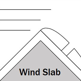
Wind Slab

With recent strong West winds and this afternoon's wind slab avalanche activity, expect areas of windslab that could be reactive, especially in sheltered areas such as below rock outcrops or in steep gullies. Slabs may be further down the slope, and ridgetop areas are likely to be scoured even on the sheltered aspects. Areas that look fat or sound hollow should be treated with caution. They could be 50 - 100cm thick. Convex rollovers should be treated with extra caution. Stability for this problem is improving, but cold overnight temperatures may slow the bonding process and we could still see significant wind slab avalanches tomorrow.
| Sensitivity | The specific avalanche problem type is reactive to human rider triggers. Easy to trigger with ski cut. |
| Distribution | Specific areas, with common characteristics. Evidence for instabilities exists, but it is not obvious and finding it requires careful observations. |
| Time of Day | All day |
| Trend | Improving |
| Confidence | Moderate |
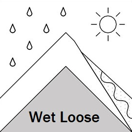
Loose Wet

The warmer weather tomorrow (30th of December) will make loose wet avalanches more likely, from mid-morning to mid-afternoon.
| Sensitivity | The specific avalanche problem type is reactive to human rider triggers. Easy to trigger with ski cut. |
| Distribution | Specific areas, with common characteristics. Evidence for instabilities exists, but it is not obvious and finding it requires careful observations. |
| Trend | Deteriorating |
| Confidence | Moderate |
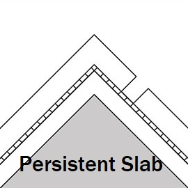
Persistent Slab

A thin layer of facets over or under a melt-freeze or sun crust has been found which is now around 1.5m below the surface. We haven't observed any avalanches on this layer yet, and it needs further investigation.
| Sensitivity | The specific avalanche problem type is difficult to trigger with a human rider. |
| Distribution | Specific areas, with common characteristics. Evidence for instabilities exists, but it is not obvious and finding it requires careful observations. |
| Time of Day | All day |
| Trend | No change |
| Confidence | Low |
Recent Avalanches and Snowpack
Today we observed a size 2.5 wind slab probably triggered by snow mobile on the SW side of Bidara (lower peak). The crown wall looks to be more than 1m thick near the top, it was about 80m wide and ran about 450m.
Glide slab avalanches on steep grassy slopes were observed at 2400m on Chrdili S - SE aspects, 27th December, and on Lomisa ridge NW-W aspects on the 28th - 29th of December.
Over the past week West winds moved a lot of snow, leaving some scoured areas with new wind slabs likely in sheltered places. 120cm of new fell in a stormy period ending Dec 26th with mostly W winds. The snowpack observed before this storm on S, SE, N and NE aspects above 3000m indicated a "right side up" snowpack with density increasing with depth. Some facets were found close to the ground on N aspects. A very thin layer of facets was found overlying a crust which is now about 1.5m below the surface. Snow tests have not show any concerning results yet, but tests have been limited.
Weather
30th of December:
Temperature minimum of -10C overnight, maximum of 1C during the day. Winds light, mostly NW, brief period of S in the afternoon.
31st December:
Temperature minimum of -13C overnight, maximum of 0C during the day. Winds light, mostly NW, brief period of S in the afternoon.
Disclaimer
Our avalanche forecasters are internationally qualified and experienced professionals, and data is provided by skilled observers. We encourage you to make your own observations and decisions, without relying solely on our forecast, since any forecast is a generalised 'best guess', and in certain cases it might be inaccurate. We can not be held liable for any actions you take in the backcountry that may result in injury, loss or death.